
Near: Lenoir City, TN (Knoxville/Maryville area)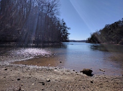
Trails: Consists of a series of trails that run along the edge of the Little Tennessee River/Tellico Resevoir. You’ll see signs on 321 past just past the Fort Loudon Dam; most of the trailheads have signs pointing to them.
From north to south, trails I have hiked are:
- Canal Branch (1.5 miles) – Runs from the Mizell Bluff trailhead; ends where 321 crosses the lake
- Baker Hollow Branch (3.2 miles) – Runs from the Mizell Bluff trailhead to Antioch Church Road. Includes the Mizell Bluff overlook. Follows the shoreline; is fairly secluded in the coves, but the times I’ve been there’s usually been boat traffic nearby.
-
Davis Ferry Branch crosses the WindRiver golf course
Davis Ferry Branch (3.3 miles) – Runs from Antioch Church Road to the Glendale trailhead. The north third (off Antioch Church Road) circumnavigates/crosses WindRiver golf course; the rest of the trail is fairly secluded. One section runs through a powerline trail.
- Glendale Branch (2.8 miles or 2.2 miles) – Runs from the Glendale Trailhead to the Coytee Branch Trail. The long version leads to “Powerline Point,” an overlook of the lake on a powerline trail. (The shortcut is also worth taking, as there’s much more greenery than on the rest of the trail.)There are two boat landings: one near the Glendale trailhead, and another close to the meeting with the Coytee Branch trail.Many of the lake views are directly across from a fairly large community/subdivision.The trail appears to cross private property at least twice. The crossing near the Coytee Branch trail sign isn’t immediately obvious when coming from the Glendale side (it’s across a grassy area on the shore of a cove, parallel to the main road).
- Coytee Trail and Loop (~1 mile from Coytee Trailhead to the loop; ~1-1.5 miles around the loop): Runs from the Coytee trailhead and connects to the Glendale Branch trail. The trail runs along a road in the River Cove community, then mostly runs through the woods away from the lake, except for the lower part of the loop. According to a map at the trailhead, there’s a campsite along this trail.
- Sinking Creek Branch Trail (4.5 miles) – Runs from the Coytee Trailhead to the Sinking Creek Trailhead. This is a pretty long hike if you’re doing a round-trip, thanks to lots of switchbacks. A few sections of the trail take you away from the lake and up along the ridge (this also means there are some climbs in places). There are a couple of boat access points along the trail.Overall, it’s a fairly secluded trail, especially with the sections that keep you away from the lake. Much of the trail takes you along coves, so you aren’t necessarily looking across the lake at residential areas as with other trails.
- Lotterdale Branch Trail (3.8 miles) – Runs from the Sinking Creek Trailhead to Lotterdale Cove Campground.
Fence crossing on the Lotterdale Branch trail
The trail can be tricky to find from the Sinking Creek end–follow the signs out of the trailhead parking lot, cross the bridge, and then take a right following Carpenter Loop Road. (In most cases, these crossings are marked in orange tape on the road.) You’ll also have to follow a trail along East Coast Tellico Parkway on the Lotterdale Cove Campground end.
This trail doesn’t have as many views of the lake as some of the other branches, and where it does seemed to have a lot of boat traffic. However, it has a good variety of terrain: both deciduous and evergreen sections of forest, often bordering meadows or pasture.
There are several small stairways that allow you to cross barbed-wire fences along the trail. (In one case, I actually had to walk across a small section of cow pasture.)
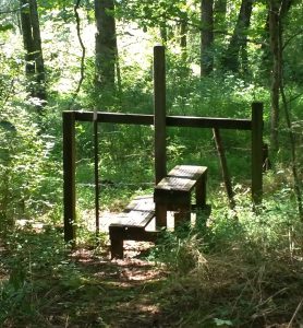
There appear to be two campsites along this trail, but they’re not marked on the map so I’m not sure if they’re actually intended to be.
-
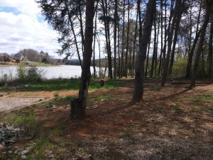
Morganton Branch Trail Camping Area
Morganton Branch (3 miles): Access from Wildcat Pointe (the south end of the trail system) and Peterson road. Lots of lake views and varied terrain, but this one has several stretches that run along the road. Also has a couple of day use areas and a primitive camping area with several campsites.
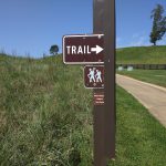
Trailheads: Trailheads I have visited are:
- Mizell Bluff: Off 321 on Jackson Bend Road. Access to the Canal Branch and Baker Hollow Branch trails, including Mizell Bluff overlook.
- Glendale Trailhead: Off 321 and 95 on Glendale Community Rd. Access to Davis Ferry Branch and Glendale Branch trails.
- Coytee Trailhead: Off 321 and 95. Turn on to Axley Chapel Road, then on to Coytee Road. Access to Sinking Creek Branch trail and Coytee Loop trail (which connects to the Glendale Branch trail).
- Sinking Creek Trailhead: Off 321 and 95, at the intersection of National Campground Road and Axley Chapel Rd/East Coast Tellico Parkway. Access to Sinking Creek Branch trail and Lotterdale Branch trails.
- Lotterdale Cove Campground: Access to Lotterdale Branch trail and Jackson Bend Branch trails.
- Peterson Road Trailhead: Off East Coast Tellico Parkway and Peterson Road. Access to the Lotterdale Branch and Morganton Branch trails.
- Morganton Trailhead: Off East Coast Tellico Parkway, in the middle of the Morganton Branch trail. Access to a primitive camping area.
- Wildcat Pointe Trailhead: Off East Coast Tellico Parkway. Has restrooms open seasonally. Access to the Morganton Branch trail.
Trails seem to be relatively secluded every time I’ve hiked them, with the exception of Mizell Bluff.
More information: http://www.outdoorknoxville.com/places/trails/south/east-lakeshore-trail
Photos: https://www.flickr.com/photos/dylan_wolf/albums/72157657978292415